Showing posts with label blog exchange. Show all posts

Friday, March 28, 2025

Why I've Blogged Since 2005

I started the Tutor/Mentor blog in April 2005, almost 20 years ago.  This Mapping blog was started in 2008 and I've been posting articles on it since 2011.

In late February a few of my #clmooc friends created posts showing why they blog and invited me to add my own history.  I invite you to read posts by Kevin, Sarah and Sheri to see where I'm getting my inspiration.

I created this image, showing me in 1997 with former Chicago Mayor Richard Daley, for my "Reflections on Why I Blog" articles. You can find the first one here.   I hope you'll take a look.

Wednesday, April 2, 2014

Using Multiple Data Sources

In the articles on this blog I've shown maps I've created using a desk top GIS mapping system, as well as the interactive Chicago Tutor/Mentor Program Locator. However, this is just one of many resources that need to be used to build a better understanding of the comprehensive problems caused by where you live or where you were born. I feel there needs to be a generation of activists who create map stories, drawing upon all of these resources.

As I find new map portals I add them to the web library that I've been building since 1998. Then I write a blog article here, or on the Tutor/Mentor Blog, to draw attention to the resource.

The map at the left is from the 2014 Annie E. Casey Foundation report titled "Race for Results: Building a Path to Opportunity for All Children" Visit the web site and view the report, as well as a recording of a panel discussion held to announce the release of the report and discuss its findings.

This second map is from a Civil Rights Project report titled "New York State’s Extreme School Segregation: Inequality, Inaction and a Damaged Future"

This third image is from the County Health Rankings and Roadmaps web site, showing health disparities in Illinois counties.

Browse this blog and you'll find links to many other map resources. Visit this section of the web library for more examples of mapping and visualization.


Each of these web sites is a tremendous resource, but they only tell part of a story. If we're to build public will to solve the problems indicated in these reports, in all of the places shown on the map, we need a massive increase in the number of people telling map stories on a daily basis, connecting maps and data from many sources into stories that motivate more people to give time, talent, dollars and votes to solve the problems these reports show to be embedded in many parts of the country.

Thursday, January 23, 2014

Using Maps and Media To Draw Resources to Neighborhoods

Today I posted a story on the Tutor/Mentor Blog showing how I've been creating map stories like this one since 1993, in an effort to build greater attention for tutor/mentor programs in neighborhoods where incidents of violence are highlighted in the media.

I've been doing map stories with the help of volunteers, and occasionally with paid staff, since launching the Tutor/Mentor Connection. Since I don't have advertising dollars, my strategy has been to follow news stories where violence, gangs and/or poorly performing schools have been giving front page, or major emphasis on inside pages of the Chicago Tribune or the Chicago SunTimes, which are the two major papers in Chicago, each reaching several hundred thousand readers a day.

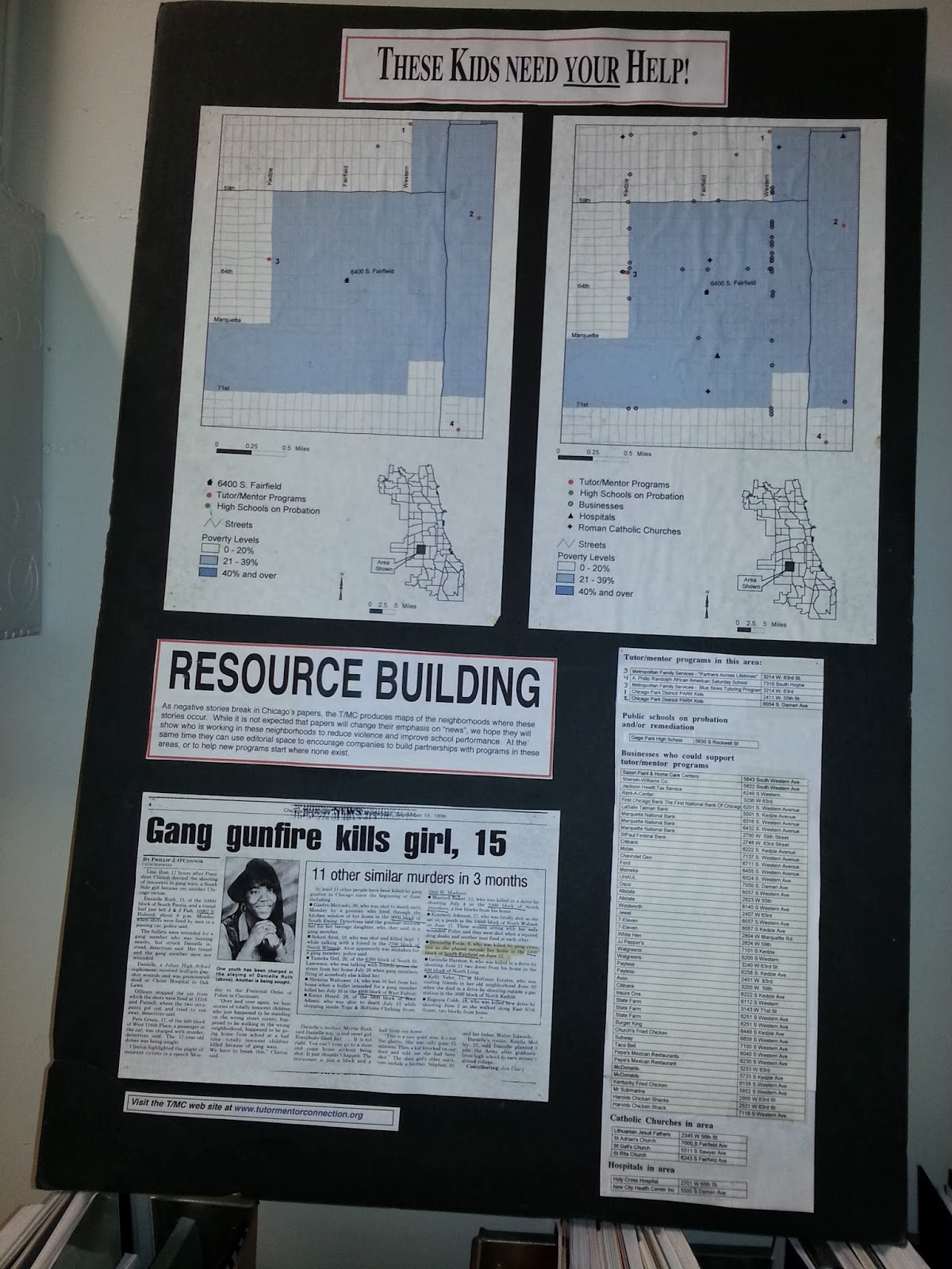
If the media story builds public interest and a desire for readers to get involved, map-stories like these can tell "The Rest of The Story", which is what the media do not do consistently include in their stories. We can show indicators of why shootings are taking place, or why students perform poorly in public schools, and we can show if there are any non-school, volunteer-based tutoring and/or mentoring programs in the area around where the story took place. We can also show some of the businesses, faith groups, hospitals and/or universities that share the same geography, and who should be strategically involved in making high quality, constantly improving tutor/mentor programs available in these areas.

Youth in middle and high schools throughout the Chicago region, and in other cities could be creating these stories, and could be involved in collecting and maintaining information about non-school programs in different neighborhoods. This article and this article offer suggestions for getting young people involved.

See additional map stories here and in the Tutor/Mentor Map Gallery.

If you're implementing this strategy, share a link to your own blog articles and connect with us on Twitter or Facebook.

Monday, April 8, 2013

How Geography of Poverty has Changed in Chicago since 1950

This Chicago Magazine article has animated poverty maps showing the change in poverty distribution in the Chicago region since 1950. Those who work for social justice, equal education opportunity, etc. should be using maps like this to plan ways to distribute volunteers and dollars into places where poor people are moving, while keeping resources flowing in places where large concentrations still live. See how Tutor/Mentor Institute, LLC use maps to mobilize resources that support volunteer-based tutor/mentor programs in the Chicago region.

Program locator - http://www.tutormentorprogramlocator.net/InteractiveMap.aspx

Map Gallery - http://www.tutormentorprogramlocator.net/mapgallery.html

Tutor/Mentor Institute blog articles - here and here

Sunday, June 19, 2011

Mapping Actions


This graphic represents the vision of Dan Bassill and the Tutor/Mentor Connection (T/MC) which began to pilot a use of maps in 1993.

This shows a cycle of collecting information about non-school, volunteer-based tutor/mentor programs operating in the Chicago region, and using maps to show where these programs are most needed, based on poverty, poorly performing schools, violence, etc. The strategy is based on what big companies like Sears, WalMart, Bank of America, etc do to support thousands of branch locations with central organizing, planning and advertising strategies.

The T/MC wants to help high-quality, constantly improving tutor/mentor programs reach kids in high poverty neighborhoods of Chicago and other urban areas in the USA and the world.

We have never had enough resources to do this so the graphic on the chart shows some actions that we do, but not with enough impact, and some actions that we will do when we find investors and partners to help us. We outline the GIS strategy on this WIKI along with other complementary strategies that make our use of maps unique.

If you want to help implement this strategy in Chicago, or in your own city, please email tutormentor2@earthlink.net and offer your time, talent and/or dollars. We cannot do as much working alone as we can with the help of others who might benefit from what we're trying to do.

Saturday, March 26, 2011

Blog at MapAdvocates talks about T/MC

Here's a blog article by MapAdvocates talking about way Tutor/Mentor Connection is applying them in Chicago. Take a look and share this with others.