Showing posts with label tech updates. Show all posts

Saturday, August 4, 2018

Tutor/Mentor Program Locator Not Working. Use This.

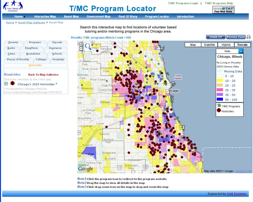
I'm sad to report that as of yesterday the interactive search page, and interactive map pages of the Chicago Tutor/Mentor Program Locator, is no longer connecting to Google maps, and thus not working.

If you browse back through articles written on this blog since 2008, or on the Tutor/Mentor blog, you'll see many examples of how I've used the Program Locator to create map stories, and how I've tried to teach others to use this.

The Program Locator not working is part of a larger on-going problem that has grown since 2011. I don't have a source of funding or technology/coding support to update the sites and/or fix problems like this.   I keep looking for new partners and/or investors, in Chicago or in any other major city in the world, who might want to take part ownership of the work I've been doing, to apply the ideas to their own community.  If you know such people, please point them to this blog and to my profile on LinkedIn.

In the meantime you can still view locations of Chicago non-school,  youth serving organizations on a map, and browse my list of more than 200 Chicago area programs, by visiting this page.

You can also visit this concept map and find several sites that you can search for contact information about tutor/mentor programs in Chicago and other US cities.

I started using maps in 1993 and have always been dependent on volunteers who could had the skills to use GIS mapping technology and/or who could put our maps on interactive web sites. I've never had the funding needed to do all that I was trying to do, nor to consistently do any of this work. However, I keep sharing the vision for the Program Locator on several wiki pages.

Vision for use of Geographic Maps - click here
Program Locator Database - overview
Vision for a future program locator - click here

Wednesday, July 6, 2016

It's Still Not Too Late

Below is a Letter to the Editor that I wrote to the Chronicle of Philanthropy in 1998. No foundation stepped forward to provide the support I was asking for, but the need still exists.


Browse past articles on this blog, and on the Tutor/Mentor blog to see how I've been using maps, which is how leaders from any city, and every sector could also be using maps.

Read this section of the Tutor/Mentor Institute, LLC Planning Wiki to see what my goal for using G IS maps has been since 1993. Read this section to see what the Chicago Tutor/Mentor Program Locator is intended to do, and to see challenges it's currently facing.

Then read this section to see a vision for using the Program Locator as a crowd-funding platform.

This can all be kept available in Chicago, or made available in any other city, if an investor/benefactor and/or partner will come forward to help.


Sunday, January 6, 2013

MapAList - Cool Address Mapping Tool

This is a new mapping application, called MapAList, that I've added to the COOL TOOLS section of the Tutor/Mentor Library.
I've been attempting to map participation in Tutor/Mentor Leadership and Networking Conferences held since 1994 to demonstrate the impact I've had in bringing programs together over a period of many years. This mapping can be done via a Social Network Analysis process or from a GIS mapping process (or both). I've never had consistent talent to do this work, and the tools have been pretty complex. Now that the technology is more available, I still need volunteers, interns and/or business partners to create these maps and communicate their meaning. Contact me if you'd like to become involved in this project.

Wednesday, April 8, 2009

A New Google-based Tutor/Mentor Program Locator!

The Tutor/Mentor Connection (T/MC) is excited to launch a new version of its online Tutor/Mentor Program Locator.

Since 1993 the T/MC has been piloting the use of a mapping technology – GIS (Geographic Information Systems) – to create tools that help build and sustain comprehensive mentoring-to-career programs in every high-poverty neighborhood in the Chicago area, while providing resources that excite volunteers, donors, and community leadership about their roles in supporting this process.


(Click on the map to see an enlarged version.)

In May 1994 the T/MC first published a printed Directory of volunteer-based tutoring and/or mentoring programs serving Chicago, and operating in non school hours. The Directory was sent to about 3000 business, foundations, schools, libraries each year until 2001. The T/MC began to put its strategy on the Internet in 1998, and posted the Directory in a searchable on-line Program Locator in 2004. Its web sites recorded more than 100,000 visitors and one million page views in 2008. A search of Google for "tutor mentor" brings the website up first among thousands of listings. The new Program Locator is the next logical step in this technological evolution.

While the original Program Locator could be searched for type of program, age group served, and zip code, with the results plotted on a Google map, the new Program Locator takes advantage of Google technologies to provide interactive access to all poverty, asset, and boundary data – the same map layers used by the T/MC mapping department when we make the maps featured in stories at http://mappingforjustice.blogspot.com/ and elsewhere on the Internet.

For those new to the concept of tutoring and mentoring, tutor/mentor programs are nonprofit facilities that offer one-to-one volunteer-student tutoring and mentoring services during non-school hours. The programs are vital to the success of college-minded and career-oriented students who are a little behind the curve due to inadequate school facilities and the challenges of high-poverty.

(Please note: There is a wide variety of organizations that offer volunteer-based tutoring and/or mentoring in the Chicago region. The role of the T/MC Directory is to help people know where they are, and how to contact them, rather than to judge which program is better than any other. Through other services of the T/MC, we seek to help each program get ideas, volunteers and resources to constantly improve and expand the quality and impact of their services. See more about this at http://www.tutormentorprogramlocator.net/ProgramLocator/disclaimer.asp )


Thanks to a generous donation received in November 2007, the T/MC hired me, Mike Trakan, in January 2008 to rebuild its desktop mapping capacity. If you scroll through the links on the side you can see the maps I’ve created since then, and articles that I’ve written to show people how they can use maps.

In each article, I use several different map images to illustrate my message. Each map shows different “layers” of information I have collected and mapped over the past year, using desktop ArcGIS software donated by ESRI. (Just a note: ESRI has been donating software to the T/MC since 1995. We would not have this capacity if these donations had not been provided.)

What’s special about the new Interactive Program Locator is that you are now able to create your own maps, very similar to the ones I make at the Chicago office of the Tutor/Mentor Connection.

In addition to plotting program locations, the new Program Locator offers a visual Google-style representation of T/MC data, highlighting relationships among existing programs, poverty, and available community resources.


With a T/MC mapping tool like the new Program Locator in hand, any community leader – from businesses, universities, hospitals, or churches for starters – can quickly zoom to a high-poverty neighborhood to see where programs are needed or missing completely. Leaders can then find geographic relationships among programs, themselves, and potential partners – and ultimately organize alliances that support existing programs or build new ones if needed.

You can review the features of the new Program Locator at http://www.tutormentorprogramlocator.net/Programlocator/TMCHelp.aspx

You can also review this animated presentation to learn more about the features of the new Program Locator: http://www.tutormentorprogramlocator.net/Programlocator/Intro.aspx

Of course, important features that were a part of the original Program Locator remain. Browse program locations to find addresses, phone numbers, contact names, hours of operation, age-group served, and website links. The new Program Locator simply offers you – the volunteers, donors, parents and youth – new depth, and an additional understanding of where support for tutor/mentor programs is most needed.


How are these maps to be used?


The articles I’ve written for the past year show how the maps can be used. I encourage you to read these. I also encourage you to read the articles Dan Bassill, President of the T/MC writes, at http://tutormentor.blogspot.com/.

We’re illustrating how maps can be used by business, religious, political and education leaders to mobilize resources that make constantly improving, volunteer-based tutor/mentor programs available to more of the children living in high poverty neighborhoods of the Chicago region. We’re demonstrating how leaders in other communities can use maps for the same purpose.

We’ll keep writing articles and creating new maps so please bookmark or subscribe to our blogs and use them as a training course for your own staff and community leaders. As you look at these maps, and articles, ask yourself these questions:

“What are the actions I or my organization can take to assure that every youth born in poverty today is starting a job and career by age 25?”

“How do we assure that there are great tutor/mentor programs in all of the neighborhoods where they are needed, rather than a few great programs in a few locations?”

“How do we help all of these programs have the resources and ideas that enable them to have a growing impact on helping kids move through school and into 21st century jobs and careers?”

To help get the creative juices flowing, Dan has collected and/or designed a bunch of strategy templates and documents which he shares in the Tutor/Mentor Institute at http://www.tutormentorexchange.net/


Please take a look at the new Program Locator and build your own understanding. Then please let us know what you think.

We want to know from you how you are using this tool. We also want to know what might work better.

Since we’re a non profit and have built this service with the help of volunteers and a few donors, we’re also looking for other people who will provide money needed to manage this service, and make the improvements that many of you will want as you begin to use the site.

Again, please post your comments below. And thank you for supporting tutoring and mentoring programs in Chicago!

Friday, August 22, 2008

New Data, Map Gallery Updates Coming

I just wanted to take a second and report on what was accomplished this week before heading out for the weekend.

We've been taking inventory of the Tutor/Mentor Connection Map Gallery, and will be updating many of the gallery maps with up-to-date data. Now, this is not to say that the maps in the gallery are out of date... all of them are still useful, and it's well worth going and poking around when you have a few minutes. But sometimes data changes over time. When this happens, it's helpful to have our gallery maps reflect these changes in order to paint the most accurate picture.

For instance, Tutor/Mentor location data is constantly changing. We store known T/M locations in our database, and T/M program info is available to you via a searchable interface, or an interactive zip code map. That data that comes up is constantly maintained and updated. Thus, whenever Nicole and Chris discover new programs or new information about known programs, our maps might look a little different.

In fact, much of my work lately has revolved around collecting current data. "Failing school" data (schools on the state's warning and watch lists) provide another example of data that are constantly changing. You've seen maps here that make use of "failing school" data, but so far I've focused solely on the Chicago Public Schools. This week, I started collecting data for schools in the collar counties. These data were actually used in two maps that I produces this week, and that Dan is currently reviewing. When I get the go ahead, I'll post them here and write about them. (If I must say so, I think they're my prettiest maps yet, so check back Monday!)

Saturday, May 3, 2008

Good to be back

Wow. I seriously underestimated how intense student teaching was going to be. It took me a few weeks but I think I finally have things under control in my lesson planning to where I can begin focusing on Cabrini Connection maps every Saturday. In another four weeks, my student teaching internship will be finished and I’ll be able to focus on these maps full time. (I can’t wait!)

Meantime, my mapping program is very close to finished. I have most of the code in place. As always when developing an application, there is a little debugging work to do. If anyone knows how to address any of these issues using VBA - ArcGIS 9.1, it would be incredibly helpful!

Here are some problems I am having:

1. I need a way to determine which neighborhood is focused when the program starts up. In other words I need to determine the center point of the visible map and determine which neighborhood polygon is overlapped with this point. A guy at the ESRI forums gave me some code which should work, but it currently does not. I suspect it has something to do with the way the layer is projected versus the rest of the layers. I’ve been lazy with my projections while trying to build the core mapping application and really need to clean this up. I've recruited David Goldblatt at Loyola for his "second pair of eyes" here.

2. I’m not sure yet how to programmatically isolate the symbols on a layer, and then modify the symbols’ color and size. You’d think this would be straight forward, but there are a bunch of different objects in the ESRI API that look very similar to what I need and I haven’t found a way to access the properties I need at this point. This will be a painful trial and error process in all likelihood.

3. If anyone knows…. how do you center the visible map to an address selected from a select box? I need to research this further.

4. Speaking of that select box above, how do you allow a user to multi-selection a bunch of addresses from a specific layer, and then tell ArcGIS to only show this partial selection of features from a shape file? Again, someone at the ESRI forum has given me code that may or may not work. I'm very open to other ideas.

5. When the user turns layers on or off, the legend resizes automatically, but doesn’t seem to want to align to the same y position in the layout, even though I have the legend object anchored to top/left. This is a minor thing, but I'd like to get it to work.

So there you have it – if I can get those to function correctly, I should be in business.


Oh – also, while I have you:

I was able to update the shapefile for Tutor-Mentor locations today, using current data.

If anyone out there knows where I can go to find updated location data for religious buildings (ie. churches/synagogue/mosque/etc.)… or local business locations, I would be eternally grateful!

More maps to come next week.

Saturday, March 22, 2008

Getting Close... Off to Student Teach...

Well, I'm off to begin my student teaching, and the program is close, but not quite where I'd like it. Most of the code is in place, but there are still some bugs that I need to address when I come in here on Saturdays over the next two months.

Also, some of the data I've been using isn't as current as it should be. I'm looking for an updated dataset for Businesses and Places of Worship - all religions. If anyone knows where I might find such data, I'd love to know... otherwise I'll be doing some research and then some geocoding.

That said, again, I'm close, and this project has been a lot of fun - learning to use ArcObjects to do something custom like this is always a trip. I'll leave you with a map I was able to make with the program this afternoon:


Any feedback encouraged!

Have a great spring... I'll check in soon,

Mike

Saturday, March 8, 2008

Tech Update: Early March Progress

Well, things weren't so smooth in general this week. Had a death in the family and my profs at DePaul are trying to kill me with papers, but I still made some improvements to the interface when I found time.

The major improvement occurred behind the scenes. I created an .ini file that stores all global variables (directories, paths, layer names). This should make it easier if I create an install package - or really if I just move it to another machine. It was a pain when I demoed for David last week, having to go into the code to change string variables manually. This file will contain all variables that are machine-specific.

I also hooked up the list boxes. Previously, Community names were coming from a flat .txt file, and the list box that will allow Dan to manually choose TMC programs from a master list were not operational at all. These list boxes read from the attribute data of the associated .shp files now. A few problems appeared this afternoon, which I will address this week. First, it takes a while to read in all values from the .shp files, so I need to create a progress bar when the tool launches. Second, I'm playing with a chunk of code that will order the attribute table prior to reading the values (to alphabetize). Haven't had a lot of luck yet.

I think that's about it this week. Oh - I played with the IMS Server data, and found nice base map/streets layers. (After a review session with ARCGis and projecting coordinate systems. Thanks again, David!)

Saturday, March 1, 2008

ArcIMS Servers seem to rule

I spent this week working alongside an intern who came down from the University of Michigan to help Dan with a flash presentation... a quick thanks to her for playing DJ all week... heard some fantastic new music!

From a tech standpoint, I was able to make a lot of progress with the interface, hooking up the remaining layers. I took the program to Loyola yesterday to demo it for my good friend, David Goldblatt, a GIS guru with Loyola's Center For Urban and Environmental Policy group, and he gave me a ton of constructive feedback.

He then introduced me to the magic of ArcIMS servers.

In my ArcGIS training, I learned to surf the web and "steal" premade shapefiles (map layers) if I needed them. If a layer was unavailable (for instance, it's hard to find premade shapefiles for IL schools that are up to date), you have to find address data and run a process called "geocoding" whereby the software tries to match the address to its database of known streets. This is problematic for two reasons (off the top of my head). First, there are new streets and subdivisions built daily... so often the software's street data can't find a match. When this happens, you have to manually match the address to a nearby street that DOES exist in the database. This takes a lot of time. Especially if there are thousands of unmatched schools. And of course, it's inaccurate. Second, schools open and (too frequently around here) close. In the shapefile I have for instance, Al Raby High School is listed as Lucy Flower Vocational. Same building... new name... old data.

So periodically my search for geocodable address data ends up at a place like this school locator. Cool toy, but how do I get to the data behind the site? Until yesterday I thought I couldn't. Turns out, Arc Catalog allows you to link to some sites' data layers using "ArcIMS Servers"!

Why did no one tell me this before? :) Now I have access to all kinds of school data, crime data from the police, transportation data ... on and on. They warehouse the data... so they maintain and update the data too. What's more, their symbols are customized and professional-looking. This almost seems too good to be true, but for now, this is going to save my uncountable headaches (until I discover limitations!)

So that is my big discovery this week. Maybe you didn't know about this either. Maybe you have more ArcGIS tips to share with me.

And I should mention that my understanding of ArcObjects continues to improve. If anyone needs help/code, maybe I can be of assistance.

Have a great week!

Monday, February 25, 2008

Tech Update: Some Progress Over The Past Week

After a bit of a struggle, the program now lets users plot multiple custom addresses to a map. Each point can have a custom symbol, and there is a tool that allows the user to track and delete points that have been geocoded and added. (It turns out that adding and deleting individual geocoded points is a little tricky to do programmatically, but after hitting my head against the wall a few times over the week, several posts on the ESRI developer board, and a bit of good luck, the system now works.) I've also added functionality that allows users to turn labels on or off for each layer included, and at this point, I'm adding the rest of the layers. I may have to create a few shapefiles myself, as some of the data here seems a little dated (CPS schools, for instance). After these layers are in place, I want polish up the zoom functionality. Still hoping to have something usable by the time I begin student teaching in late March.

Saturday, February 16, 2008

Tech Update: Rolling Up My Sleeves

Ok... this week has been full-on trouble shooting and learning how to make the code behind the software's engine do what I need it to do. I have programmed with Visual Basic in the past, so I'm comfortable with the VBA editor that comes with ArcGIS. On the other hand, the object model for ArcGIS is humongous! I've had success in the past using the object model, but it's always an adventure, and my success is owed entirely to the many support/help resources I've found. The fact is that many people have published their code online, so I haven't had to invent many wheels so far.

I'd like to take a second and share my sources, in case anyone out there is interested in coding ArcObjects but just starting out. And of course, any of you veterans who know of more/better sources, please send em my way.


First, I should mention that I do use my trusty copy of Getting To Know ArcObjects by Robert Burke a lot. But not nearly as much as online sources such as ArcObjects Online and The ESRI Developer Network, each of which offer a lot of documentation and code samples. But the ESRI User Forums is the goldmine. Usually my first stop - highly recommended and helpful.

So, what have I accomplished so far (with the help of these resources)? For starters, I have learned how to zoom to the boundary of a polygon, such as a neighborhood or a the boundary of zip code. The volunteers here might want to make a map of the Albany Park neighborhood. They can do this now with the click of a mouse, thanks to code which came largely from the Burke book.

I have also learned how to programatically geocode a custom address (although I have had problems refreshing the geocoded point to appear on the layout once it is added to its attribute table. Still unsolved but I'm not out of ideas.)

In fact, refreshing the map layout is more complicated - in general - than I had anticipated. A guy in India on the ESRI boards helped me troubleshoot my code when I was having a hard time accessing and refreshing the legend. (Thanks, Vijay!) Maybe this technique will shine light on why my geocoded point won't refresh. I'll get that fixed this coming week.

What else did I build this past week? There is now a way for the user to customize the title, add news text, and add credits/sources to the map. Again, this was a little more difficult than I suspected it would be, since the text objects' property dialogs do not let you give them unique IDs/Names... and you need to refer to the objects by name when accessing them programatically. No idea why you can't simply rename them in their property boxes. Turns out, I had to create a custom routine to name the components, one at a time, at the moment I created them. Strange, but it worked. (Drop me a line if anyone needs any of this code.) Moreover, I had to add code to add carriage returns to user text (news stories), in order to ensure the textbox object stays at the proper width in the layout. (If that makes sense.)

I have also learned how to access layers in the Table of Contents (toc), and how to toggle them on and off. Again, refreshing the toc is separate from refreshing the map... and then refreshing the legend - all of which have to occur when a layer is toggled on or off. But now that I can do all of this, adding the layers Dan needs (hospitals, schools, teacher/mentor program locations, etc.), and attaching them to the interface will be tedious but straight-forward.

Lastly, I should mention that a guy who lurks on our yahoo group TutorMentor_GIS_Project works for the city of Chicago, and contacted me with a donation of code that allows me to export map layouts to .pdf ... thanks!

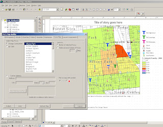
That should get us up to date for the week. Here's a quick look at the interface in its current state:

See you next week.

Thoughts and prayers to everyone who lost their home in this week's fire at Cabrini Green. Heartbreaking story.