
The two photos show me with a 7th grade student, who is now a college graduate with two kids in college. We're still connected on Facebook.
The second is a map of Chicago, with high poverty areas highlighted, and known volunteer-based tutor/mentor programs shown.

We named that Tutor/Mentor Connection and launched our first survey to learn about existing programs in January 1994.
Why maps?
Why maps?
In late 1992 as I was forming the new program I told a librarian at the United Way/Crusade of Mercy about our intent to learn about every tutor/mentor program in Chicago. She asked, "How will you share that information?"
I told her I had not yet figured that out and she went into the library and came back with a magazine that describe Geographic Information Systems (GIS) and how that could be used to plot locations of programs on a map of Chicago.
I was immediately sold on the ideas and have spent the last 30 years trying to do that.
The first challenge was learning about GIS technology and building the capacity to create maps. That was solved in 1993 when Metro Chicago Information Systems offered to produce maps for us (for a fee). They produced maps for us through 1995. We launched our own capacity in 1996 (see below).
How were maps used?

A second strategy was to create map-stories following negative news in the Chicago SunTimes or Chicago Tribune. Below is one example.

We added locations of tutor/mentor programs in the area, if there were any. Then we also added layers showing assets, such as churches, business, colleges and/or hospitals, who shared the geography, thus should be strategically involved in helping tutor/mentor programs grow, and helping those programs constantly improve what they were doing to help kids through school and into jobs and careers.

The goal has been to have good and constantly improving programs in EVERY high poverty area, not just in a few places.


Over the past few months I've been creating archives in my Google drive folder and now you can look at all of the maps and map stories we've created, as well as the media stories our strategies generated.
Map stories created since 1993 - open this link

From 2008 to early 2011 we were able to hire a part time GIS expert to create maps using donated ESRI ArcView GIS software. View his collection.

The collections below show maps used in blog articles, visual presentations, social media, etc. Many of these maps were NOT created by the Tutor/Mentor Connection or Tutor/Mentor Institute, LLC. Some were created using the interactive map-based program locator that was created in 2008 - open this link


Last Friday I posted an article on the Tutor/Mentor Blog, featuring a PDF presentation showing my "30-year history of reaching out to universities". Below are three pages from that presentation
Students from Northern Illinois University set up a GIS map-making capacity at our Cabrini Connections office in 1995. One student worked for us part time in 1996 and 1997 to create maps for us, then continued as a volunteer.


As we found ways to create maps and map-stories we created an on-going event strategy that generated media stories. Below is a folder that shows several hundred articles.

Finding talent to do the annual survey, create and maintain a database, and then create our maps was always a challenge. Drawing attention to the maps was an equally large challenge. That's why I began to reach out to universities in 1993 to try to form partnerships that would lead to students, faculty and alumni duplicating the work my small organization was piloting.
Last Friday I posted an article on the Tutor/Mentor Blog, featuring a PDF presentation showing my "30-year history of reaching out to universities". Below are three pages from that presentation
Students from Northern Illinois University set up a GIS map-making capacity at our Cabrini Connections office in 1995. One student worked for us part time in 1996 and 1997 to create maps for us, then continued as a volunteer.

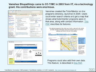
Vamshee Bhupathiraju, a graduate student at IIT, came to Cabrini Connections, Tutor/Mentor Connection in 2003 through a technology grant. He created the on-line program locator, which was launched in 2004. This was the source of data used in the interactive Chicago Program Locator built in 2008 by a team from India.

Students from Indiana University created a map in 2016, showing participation in every Tutor/Mentor Leadership and Networking Conference from May 1994 to May 2014.

These were significant contributions. These are just 3 pages out of 50 that I share in this presentation. They show what's possible. I hope you'll take a look.
I'm sharing my archives because I believe other people could do what I've been trying to do, and do it better. And because I'm now 77 and need others to continue this work.
My maps show that non-school, volunteer-based, tutor, mentor and learning programs are needed in many parts of the Chicago region, but in many cities around the country (and probably the world).
My maps show that non-school, volunteer-based, tutor, mentor and learning programs are needed in many parts of the Chicago region, but in many cities around the country (and probably the world).
Too few people ever saw the maps I'm sharing because I never had millions of dollars for advertising and was not a Taylor Swift type of celebrity who could draw people to complex ideas on a regular basis.

Universities have the talent, and responsibility, to do this work. However, unless major donors step forward to provide on-going, decades-long, funding, none will do this for as long as I have and none will ever be able to publish an archive like I've shared here, showing 30 years of maps and map stories.
Ten or fifteen years from now archives like mine could be available on university websites in many cities. It only takes "two or three people on a campus to launch a Tutor/Mentor Connection", and a major donor!
I'll be sharing more of my archives in coming weeks, primarily in articles on the Tutor/Mentor blog. My goal is that a few people will be motivated to dig deeply into this information. I'm sure there's a book that could be written, showing strategies leaders can use to help end poverty by helping more kids through school and into jobs and careers.

Thanks for reading this. Please share it.
I'm on Twitter (x), Facebook, LinkedIn, Instagram and other platforms. You can find links on this page.
I'm on Twitter (x), Facebook, LinkedIn, Instagram and other platforms. You can find links on this page.
If you are able to make a small contribution to help me keep doing this work, visit this page.
No comments:
Post a Comment